| |
| Stretch: |
Downieville to highway 49 bridge |
| Difficulty: |
class IV with 4 class V rapids, harder at high flows |
| Distance: |
12.2 miles, 1 day |
| Flows: |
rafts 800 - 3000, kayaks 700 - 2500, IK minimum 600
|
| Gauge: |
flow measured at Goodyear Bar
(USGS site)
|
| Gradient: |
60 fpm to Goodyear Bar, 49 fpm afterwards |
| Put-in: |
beautiful downtown Downieville, 2880' |
| Take-out: |
highway 49 bridge, 2220' |
| Shuttle: |
13 miles (20 minutes) one-way |
| Maps: |
Plumas NF, AAA Feather and Yuba,
Topo
|
| Season: |
spring into early summer, from snowmelt |
| Agency: |
USFS, private,
guided Whitewater Rafting |
| Notes: |
© 1998, 2013 Bill Tuthill,
CreeksYahoo |
The Holbek/Stanley book says the stretch below Goodyear Bar makes a good
intermediate run, but parts of this 9 mile stretch are quite tough.
Besides class V- Maytag, boaters must contend with two solid class IV rapids,
Two Pair and Son of Maytag.
It might be better to call this an advanced run and combine it with Rossasco Ravine upstream.
Although nearby highway 49 degrades the scenery somewhat,
it does provide a convenient escape route if the river proves too much for you.
Here is a raft-cam video of the hardest rapids below Goodyear Bar
by Gregory MB.
As is typical of many trips, they make it thru Maytag but flip in Son of Maytag!
At high flows, boaters sometimes swim for a long distance in cold water.
In 1995 one commercial rafting passenger died after such a swim at 4000 cfs.
I personally know one woman who would have perished if an alert camper
had not plucked her from the water above the highway 49 bridge.
Upstream in Rossasco Ravine, a high-water 1995 commercial rafting death
is listed in the AWA accidents database, but my memory is that more deaths
have occurred on that section of the North Yuba.
A kayak run at lower flows is attractive for two reasons:
first, there is less chance of flush drowning, and second,
the weather is much warmer in late spring or early summer, when flows recede.
Although the Holbek book lists 700 cfs as the minimum flow,
this is because of wide and shallow boulder bars that are pin hazards,
so inflatable kayaks work at 600 cfs or perhaps lower.
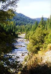 The North Yuba at low water in October
The North Yuba area makes a fine destination,
with plenty of good camping and fine dining in Downieville,
a mountain biking mecca.
Reservations are recommended for motels in Downieville;
see websites for the Downieville Inn
and the Riverside Inn.
There are also plenty of USFS campgrounds in the area.
After Memorial Day, campsites are hard to get on Friday evening.
- mile
0
- Put in on the right bank below the first bridge undercrossing.
- .8
- Rossasco Ravine begins, and continues for over a mile. This section
becomes more difficult and dangerous as flows increase.
- Big Dummy, the first class V rapid, is a chute into a tremendously
large hole that gets sticky at high flows. Portaging is possible
on the left (AKA Cathy's Carry).
- The next rapid, class V- Flake, involves a narrow chute between
large flakes of a huge boulder. Some small boaters choose to run
it, but there is an easy portage just to the left, which becomes a
runnable chute at higher flows.
- Next comes Little Dummy, a smaller version of its upstream namesake.
Be careful at high flows because of the rapid below.
- Just downstream is class V- Parallel Parking (AKA Giant Slalom),
a complex boulder slalom. This can be portaged on the right,
perhaps with aid of the road.
- 2
- Rapids taper off to merely class II.
- 3.5
- River access on river right near the town of Goodyear Bar.
Plenty of parking and a good trail down to the river, reachable
on highway 49 about 1/4 mile past the Goodyear Bar turnoff.
- 4.2
- Rock Creek enters on the right. Some class III boulder bars appear.
- 5.7
- Ramshorn, class IV-, possibly island scout
The river splits around islands. The center channel, eventually
feeding to the right, has (in the past) had the most water, but
is still bony at low flows. This rapid is rated class IV because
strainers can wash into and get caught in the center channel.
- 8.9
- Two Pair, class IVe, scout right, maybe left
A class III rapid leads to the brink of a bedrock outcropping that
creates a tricky rapid at most flows. On the right, the first drop
is slanted and uneven, causing a tough entrance into a calmer channel
above the second drop, which is more straightforward. Oddly enough,
you might want to go sideways over the first drop to reduce your tilt.
The left side would appear to offer a sneak route, although a rafter
was pinned and died there in April 1999. In June 2000 a kayaker was
pinned and died on the right side. Two Pair's class 4E rating means
class IV difficulty with class V danger.
- 10.1
- Humbug Creek enters on the left at a large rock outcropping.
- 10.2
- Maytag, AKA Mixmaster, class V-, scout left or right
A steep foamy chute pours into a large hole, backed up by a rock
just downstream; the left wall juts out just below that. Enter
left of center, because there is a bad undercut on the right side.
If not immediately followed by a class IV, Maytag might be less
feared. Photo sequence © 1998 by raft guide Nick Aghazarian
(www.AceProgrammer.com),
appearing with permission.
-
- 10.4
- Son of Maytag, class IV, scout while scouting Maytag
Just below a curling wave that flips many rafts whose crews got
overconfident after Maytag, the current bends left. Swift class II-III
water continues for a distance, exacerbating the risk of long swims.
- 12
- Fiddle Creek Campground, possible take-out.
- 12.2
- Carlton Campground, last possible easy take-out.
- 13
- Highway 49 bridge, with plenty of free parking but steep banks.
Downstream, class IV rapids continue for 6 miles to the slack
water of New Bullard's Bar reservoir. Whitewater Voyages offers
commercial rafting trips on this stretch, with houseboat partying
while you wait to motor 12 miles to vehicle access.
Shuttle Directions
To reach take-out, drive north from Nevada City on highway 49,
crossing the south and middle forks of the Yuba.
When highway 49 descends to the north fork Yuba,
you see many USFS campground along the river.
You can take out either at these campgrounds, or at the bridge.
To reach put-in from there,
continue upriver until reaching the town of Downieville.
Park in the public square on the right.
A beach and river bridge are nearby.
To find nearby food and lodging, type Downieville into the box and click Search.
|
|
Creeks Navigation
Home
Recommended Runs
Map of Rivers
Alphabetic Index
Alphabetic Table
Text Search
Sponsored Links
|

 The North Yuba at low water in October


