Lower South Fork Merced River


Stretch: Snyder Gulch to main Merced confluence
Difficulty: class III with several class IV rapids
Distance: 7.2 or 4.9 miles, 1 day
Flows: rafts and kayaks 500 - 1500 cfs
Gauge: estimate 35% of the flow at Briceburg (MBB)
Gradient: 53 fpm average
Put-in: at Snyder Gulch or along Hite Cove road, 1780' or 1660'
Take-out: in right-of-way at South Fork bridge, 1400'
Shuttle: 30 or 35 miles (1 or 2 hours) one-way
Maps: Yosemite NP, AAA Yosemite, Topo
Season: spring into early summer, from snowmelt
Agency: USFS, BLM, private
Notes: © 2002 Bill Tuthill, CreeksYahoo

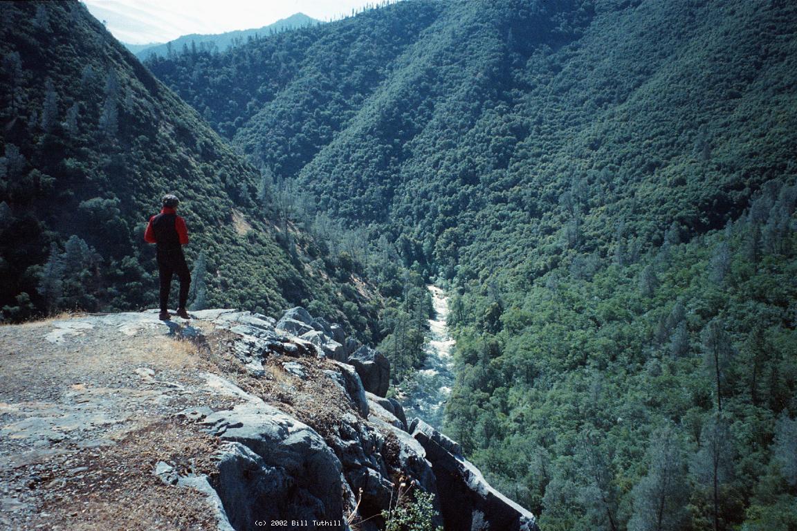
Lars Holbek describes the South Fork Merced below Wawona as a classic, one of the best multi-day class V+ runs in the world. This writeup describes two approaches to a much easier lower-elevation run, one involving a hike down, the other requiring 4WD vehicles with skid plates. You might want to boat this “downshifted” river (in Holbek terminology) if you're not yet ready for the serious run starting at Wawona, or if you want to see what the classic run looks like after mile 14. Mark German (mgerman@attbi.com) put in at Snyder Gulch and reports:

A buddy and I did that run about four years ago. The scenery was great and we saw no one else. I have pictures of us at the top pumping up our IKs in a near blizzard. In fact my buddy carried tire chains in his IK so I could shuttle my truck up to the put-in when we were finished. We also encountered relatively large bear tracks in the snow while dragging our boats down to the river. Thought you might find the story interesting.

Poised at the top of Hite Cove 4WD road in my Trooper, I felt like an intermediate skier at the top of a steep expert trail for the first time. But my vehicle made it down, acquiring many new poison oak scratches, and bottoming out only once. On the return shuttle (with no boats), Boris drove his Pathfinder without bottoming out at all. This 4 mile portion of the shuttle takes over an hour. With just a regular car, you can easily reach the end of a dirt road where a trail descends 2000' in 3.5 miles to a higher put-in.

mile
0
On the South Fork above Snyder Gulch is a steep section with undercut rock that Holbek mentions in his guidebook. Below Snyder Gulch the river widens over gravel bars and splits around an island at higher flows.
.5
Where the canyon narrow is a long rapid, probably class IV.
.7
The river forms a large pool, with Sims Cove on the right.
.8
After a sharp left turn is another long, probably class IV rapid around a small island.
1.2
As the river bends right, rapids pick up speed and continue for a while, though not as intensely as above.
1.4
The river bends right again and rapids pick up their pace into a miniature gorge. At high water, bedrock drops can be sticky.
2.3
Rapids ease as Hite Cove 4WD road approaches on the left, and Nutmeg Gulch comes in on the left as a small creek. Good campsite. Other good campsites are further down Hite Cove road on river left.
South Fork Merced River CA South Fork Merced River CA
Turning the corner around Marble Peak Good rapids between Snyder and Nutmeg Gulch
2.9
After a few gravel bar rapids, bedrock appears and boaters encounter two major rapids in a row, the second less difficult but harder to boat scout.
3.7
Hite Cove on the right, a large open area where hikers appear from downstream. Nobody crosses on the 4WD trail to Hite Cove during boating season because of high water.
4.6
Another major rapid over bedrock, where big waves surf boaters towards the left wall.
5.9
Last major rapid, where a house rock stands to the right of a big drop with large holes.
7.2
Take out just before the highway 140 bridge over the south fork. Nearby picnic tables appear to be on unposted private land.
To reach take-out, drive east from Mariposa on highway 140 towards Yosemite. After the road crosses Mid Pines summit and descends to the river, you see the BLM office at the former town of Briceburg. From this point, continue upriver about 10 miles to a small turnout and gated driveway just downstream of the South Fork bridge. On the other side of the South Fork are resort, trailhead, and more parking.

To reach put-in from there, retrace your route uphill to the motels and stores of Mid Pines. Short of the summit, turn left on Triangle Road. Proceed up and downhill for about 10 miles to a major intersection with Darrah Road to the right and Jerseydale Road to the left. Turn left and proceed another 10 miles to the end of the pavement. Good campsites are available in this area. Take the right fork instead of going to Jerseydale. Proceed past residences over 2 miles to another fork with sign saying “Hite Cove Road 2 miles” and bear right again. From there it is only 1.3 miles to a gate where Hite Cove Road begins. At that point you can choose to make a sharp right turn onto an easy dirt road leading gently downhill to the trailhead, or you can proceed thru the gate steeply downhill to the river. High clearance 4WD is mandatory; skid plates and low range are recommended.


 Creeks Navigation

 Home
 Recommended Runs
 Map of Rivers
 Alphabetic Index
 Alphabetic Table
 Text Search

 Sponsored Links