| |
| Stretch: |
Blue Slides Creek to Pillsbury Reservoir |
| Difficulty: |
Class II with one III and one possible Class V |
| Distance: |
8 miles (1.5 on reservoir), 1 day |
| Flows: |
400 - 1000 cfs |
| Gauge: |
none, but runnable after recent rain |
| Gradient: |
31 fpm average, highest in mile 4-5 |
| Put-in: |
Forest Service Road M10, 2020' |
| Take-out: |
Pillsbury Reservoir, 1818' |
| Shuttle: |
15 miles (.5 hour) one-way, all on dirt roads |
| Maps: |
USFS Mendocino NF, AAA Sonoma and Mendocino |
| Season: |
March perhaps into June, rain and some snowmelt |
| Agency: |
USFS |
| Notes: |
© 1998 Bill Tuthill,
CreeksYahoo |
Sometimes a river beckons from a map, asking you why
nobody has bothered to run it and write it up in a guidebook.
This is one such river, although after a run in May 1998,
we know why this segment doesn't appear in any guidebook.
Although its gradient of 31 fpm seemed promising,
most of this action comes in two successive rapids around mile 4.5.
The rest of the river is class II at most.
To add insult to injury,
the trip ends with a long paddle across Pillsbury Reservoir.
-
mile
0
- Put in where forest road M10 fords the river just below its
confluence with Bear Creek, the tributary with the most snowmelt.
Do not attempt to ford the river unless you're sure you can make it.
The picture shows what happens if you aren't careful.
-
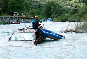 The river had its way with this truck
-
- Class I and occasional class II rapids for about four miles.
- 1.5
- Bevans Creek enters on the left.
- 2.5
- Rice Creek enters on the right.
- 4.4
- Mariboho's Blowout, class IV+ or V-
This rapid contains many undercut boulders and seems best to run
on the right (1998). It is named after Keith Mariboho, who popped
his Padillac while attempting to line this rapid. Moderate portage
(with sharp rocks and bushes) on the left.
-
- 4.5
- Deer Creek enters on left, then the river bends sharp left.
-
- Anticlimax, class III
Just below Mariboho's Blowout, this is the second most exciting
rapid on the run. Afterwards, class I rapids continue unabated.
- 5.4
- Willow Creek comes in on the left.
- 6.5
- Slack waters of Pillsbury Reservoir. Continue paddling about 1.5
miles to a primitive boat ramp on the left connected to a dirt road.
To reach take-out, take Potter Valley Road north from Highway 20, and follow
signs to Pillsbury Reservoir. Near Van Arsdale, follow the south side of the
river on Elk Creek - Potter Valley Road (River Road) to where forest road M1
turn uphill to the right. Follow this towards the reservoir, and descend on
a minor road to a primitive boat ramp up the Rice Fork arm.
To reach put-in from there, return to M1 and continue southwest and south
for about 9 more miles to Bear Creek Road, M10. Turn left and descend about
5 miles to the river.
|
|
Creeks Navigation
Home
Recommended Runs
Map of Rivers
Alphabetic Index
Alphabetic Table
Text Search
Sponsored Links
|
 The river had its way with this truck


